

MARINE ELECTRICAL RESISTIVITY IMAGING

Direct current (DC) electrical resistivity is a geophysical technique that has long been used to characterize the subsurface. Marine electrical resistivity imaging (ERI) combines the precision of DC electrical resistivity methods with the collection speed of traditional EM techniques. By towing an electrode array behind a ship and continuously recording data with the AGI SuperSting R8 Marine© unit, the marine resistivity set-up can record many times the line-distance of traditional electrical resistivity land systems. Applications include characterizing sediment type (sand vs. clay), identifying zones of submarine groundwater discharge, and mapping geologic structures. Here is a detailed discussion of marine ERI.

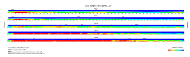

Profile Lines Collected with Marine ERI